Fires - Wildfire Info & Atlas
By Ryan Strouse
- Category Navigation
- Release Date 2016-09-08
- Current Version 4.1.1
- File Size 46.77 MB
- Links Google Play
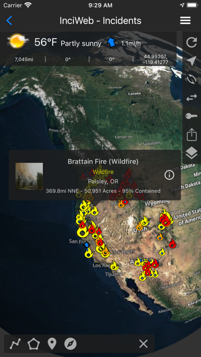
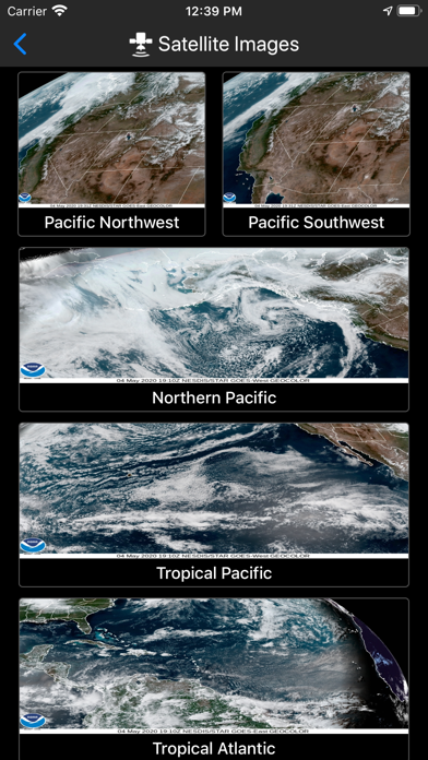
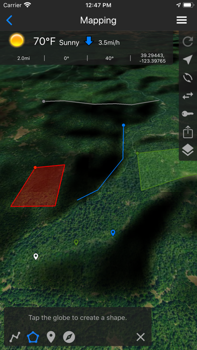
Fires is a comprehensive wildfire information resource and atlas. ▶▶ WILDFIRE INFORMATION RESOURCE ▶ Incident Details Fires provides maps, photos, and information about wildfires from several sources for the United States. View active wildfire perimeters or share wildfire information and high resolution photos. • InciWeb • CAL FIRE • NIFC • US Forest Service ▶ Incident Notifications with Containment Updates Fires will notify you when new incidents are downloaded within the maximum distance that you set from the source that you select. • InciWeb • CAL FIRE • US Forest Service ▶ Offline Incident Mapping Fires can automatically download incidents when the app is in the background from the source that you select. • InciWeb • CAL FIRE • US Forest Service ▶ Thermal Hotspots and Fire Activity Fires allows you to interactively browse the full set of global active fire detections from MODIS and VIIRS. • Collection-6 MODIS Active Fire Data • VIIRS I-Band 375m Active Fire Data • Active Fire Details ▶ GOES and Himawari Satellite Images and Animations Fires provides extensive near real-time GOES (Geostationary Operational Environmental Satellite) imagery from NOAA. • United States • Pacific • Atlantic • Central America • South America • East Full Disk • West Full Disk ▶ Local Weather Conditions Fires gives you a summary of your current local weather conditions from AccuWeather for free without a subscription. ▶▶ ATLAS ▶ Offline 3D Maps and GPS Fires will give you offline GPS functionality and 3D maps when there is no network coverage. • Several Basemaps • 20 Bureau of Land Management (BLM) Reference Maps for California, and we are currently adding many more to this collection. • 21 United States Forest Service (USFS) National Forest Maps for California, and we are currently adding many more to this collection. • Create Lines, Shapes, and Waypoints • Navigate and trace your locations ▶▶ SUBSCRIPTIONS Subscriptions automatically renew unless auto-renew is turned off at least 24 hours before the end of the current period. Your iTunes account will be charged for renewal within 24 hours of the end of the current period, and identify the cost of the renewal. ▶ FIRES PRO ELITE ($19.99/year) Yearly access to the entire Fires Atlas, this includes unlimited access to all the Basemaps, BLM reference maps, and USFS reference maps. • Access Incident Weather Conditions. • Remove Ads. • 7 day free trial. ▶ FIRES PRO ($14.99/year) Yearly access to all the Basemaps along with yearly access to 4 BLM and USFS reference maps. Each reference map selection will last for 3 months at a time. After 3 months each reference map selection expires, then you can change that selection to any other reference map in the Fires Atlas. • Access Incident Weather Conditions. • Remove Ads. • 7 day free trial. ▶ INCIDENT WEATHER CONDITIONS ($5.99/year) • Access Incident Weather Conditions ▶ REMOVE ADS ($2.99/year) • Use the app without ads ▶ TO MANAGE YOUR SUBSCRIPTION: • TURN OFF auto-renewal via the main Settings app: http://support.apple.com/kb/ht4098 • Subscriptions automatically renew unless auto-renew is turned off at least 24 hours before the end of the current period. Your iTunes account will be charged for renewal within 24 hours of the end of the current period, and identify the cost of the renewal. • Your iTunes Account will be charged at confirmation of purchase. • Visit the following URL to view our Privacy Policy: http://www.livewaremedia.com/p/privacy-policy.html • Visit the following URL for full terms of use: http://www.livewaremedia.com/p/terms-and-conditions.html